Alaska study compares ground motion, magnitude estimates from satellite and seismic records
When it comes to making a rapid estimate of ground motion and moment magnitude for an earthquake, using data from Global Navigation Satellite Systems (GNSS) might be a good alternative or addition to data from seismic stations.
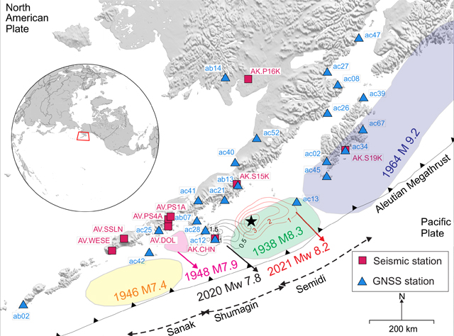
Researchers were able to compare how well each type of data performed in assessing the 2021 magnitude 8.2 Chignik earthquake in Alaska, as they report in the journal Seismological Research Letters.
The study by Revathy Parameswaran and colleagues at the University of Alaska, Fairbanks shows “that GNSS and strong-motion acceleration seismic data can be interchangeably or jointly used for rapid magnitude or ground motion estimation,” said Parameswaran.
When a large earthquake takes place in a region with mostly broadband seismic stations that record the velocity with which the ground moves, the amplitude of seismic wave velocities can exceed what the station can record, leading to a loss of data, she explained. “In such a situation, we can include GNSS data to improve network density or spatial coverage to estimate magnitude and ground motion rapidly. This also applies to regions that have sparse strong motion coverage.”
Researchers studying earthquakes increasingly use GNSS data to capture the deformation of the ground from earthquakes or to monitor slow movement along faults. One way that GNSS can be used to characterize earthquakes is by converting GNSS data into receiver velocities. Those velocities can then be used to calculate traditional earthquake measures such as magnitude and peak ground velocity.
The researchers had initially planned to study different earthquakes using GNSS-derived ground velocities, although they were also ready to compare GNSS and its seismic data counterparts.
“The 2021 Chignik earthquake provided a great data set to do this,” Parameswaran explained. “The Chignik event was large enough to generate substantial ground motion even hundreds of kilometers away, had a healthy network of stations with usable data, and most importantly, co-located GNSS and seismic stations that could be used to make the actual comparisons.”

Seismic and GNSS station coverage for the 2021 Mw 8.2 Chignik earthquake. | Parameswaran et al. (2023), SRL
One limitation of GNSS with today’s instruments, Parameswaran said, “is that data is largely sampled once or five times every second—1 to 5 hertz—while strong-motion instruments record data 50 to 100 times a second, or 50-to 100 hertz.”
“If the earthquake causes the ground to move faster than GNSS records it, the characterization might not be as accurate as we would like it to be — we might not sample the full range of motion,” she added.
California, New Zealand, Japan and other regions with extensive seismic and GNSS networks and large earthquakes would be good places to continue testing the usefulness of GNSS earthquake characterization, the researchers noted.
“Any earthquake large enough to be recorded by co-located strong-motion seismic and high-rate GNSS stations should be capable of replicating the type of result we obtained using the 2021 Chignik earthquake,” said Parameswaran. “Therefore, our take is that GNSS is a potent addition and a fail-safe to seismic data.”