How satellite data make flying safer
Key points
- Satellite data allow Hampus Sellman, an aviation forecaster at the Swedish Meteorological and Hydrological Institute, to predict dangerous flying conditions
- Aviation forecasts rely on timely Earth observations
- Detailed satellite observations from EUMETSAT's Meteosat and Metop programmes support this work
In April 2024, aviation forecaster Hampus Sellman was setting up for an early shift at the Swedish Meteorological and Hydrological Institute (SMHI) when he received a call from a light aircraft pilot worried about the current weather conditions.
"Medium-range forecasts had predicted cold weather and nearly clear skies, however, when I checked the latest satellite images, I saw it was overcast the whole way," says Sellman, who is based at SMHI's local office in Uppsala.
"This immediately raised alarm bells: one of the biggest hazards for pilots during cold, cloudy conditions is the potential accumulation of ice on parts of the aircraft, which can impact the control and performance of the vehicle and interfere with its systems.
"However, the precise conditions that can ultimately lead to aircraft icing are very hard to predict. It's not enough to view weather forecasts, pilots must recognise and react to the conditions in the moment."
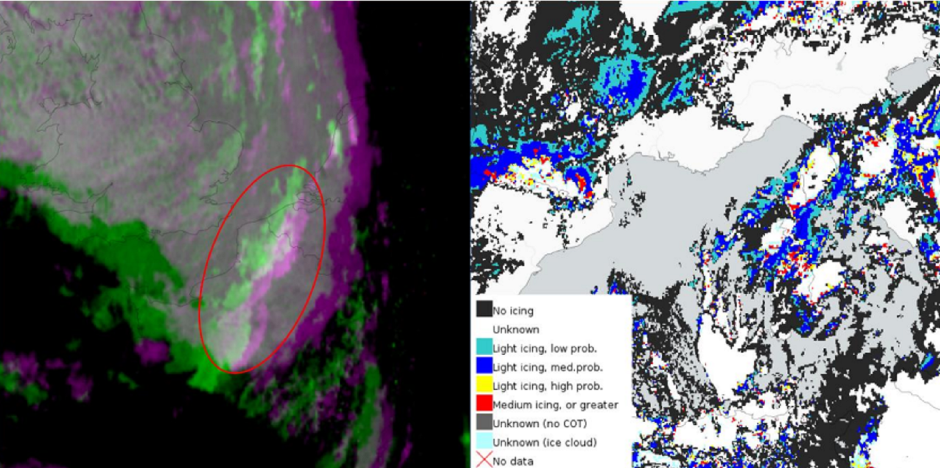
Aviation weather experts such as Sellman are trained to interpret a wide range of near-real-time observations made by ground-based radar and sensors on aircraft and meteorological satellites such as EUMETSAT's Meteosat and Metop spacecraft.
"Using near-real-time satellite images, atmospheric sounding data and other observations, we saw factors such as the temperature, humidity, and cloud droplet size had the potential to cause concentrated ice build-up on the aircraft," Sellman says.
"I could see the conditions were bad, and having experienced previous events where clouds had failed to dissipate as weather models had anticipated, I advised the pilot he should remain grounded."
While this was not the message that the pilot had been hoping for, interactions between aviation weather experts and pilots help to minimise risks to flight safety: even though a lot can go wrong, things hardly ever do, and today flying is widely regarded as the safest means of transport.
"To predict the development of potentially dangerous conditions, aviation weather specialists must work to extremely tight timescales, just a couple of hours in advance," Sellman says.
"Data products produced using near-real-time satellite observations can help us to characterise air masses, monitor atmospheric motion, observe the distribution of clouds, and track areas of instability.
"We have a wide user base including pilots, air traffic controllers, airport workers, flight schools, and search and rescue teams. Our aim is to provide them with even better forecasts than weather prediction models over the short term."

Source: EUMETSAT
Weather warnings
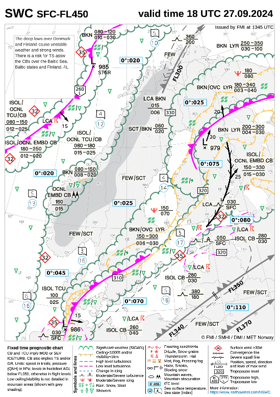
When dangerous conditions are predicted in an airspace commonly used by pilots, Sellman and his team issue warnings for significant meteorological phenomena, known as SIGMETs.
"SIGMETs may be issued during conditions such as severe icing or turbulence," Sellman says. "For example, air oscillations known as 'mountain waves', where winds that cross over mountains create gravity waves that can occasionally break, can lead to severe or even extreme turbulence, which can be damaging to aircraft of all sizes.
"Pilots are therefore required to reroute or avoid areas of airspace for a defined period. As this can be very disruptive to operations, the advisories are constantly updated.
"However, forecasters must often make decisions based on limited or subjective information: for instance, pilots reporting hazards such as turbulence can give different accounts when flying through the same airspace at a similar time.
"Therefore, tools such as meteorological satellite data are critical for gaining a broader picture of the many different parameters contributing to hazardous situations.
"Predicting how such situations will evolve in the next hours is critical to ensuring that pilots do not enter an airspace when conditions are unsafe, and on the other hand that they also have confidence that when they are in the air, they can proceed safely, as planned."
Improving safety
Another common reason to issue a SIGMET is when there is a high risk of thunderstorms. When Sellman was a child, rather than run for cover during a storm, he would head towards it, camera in hand, hoping to snap a picture of the lightning.
"I never once succeeded!" he says. "It's very hard to take a picture of lightning with a regular camera, however, this fascination was one of the reasons I became a meteorologist, where observing lightning is a critical part of our work.
"By building up the amount and types of near-real-time lightning observations, it will be possible to further improve warnings and aviation safety.
"For example, new lightning data from EUMETSAT's Meteosat Third Generation Imager (MTG-I) satellites will help us to locate clusters of lightning activity, especially lightning occurring within and between clouds. This will be a tremendous complement to ground-based networks of sensors and allow us to better determine the location and intensity of storms.
"The Flexible Combined Imager (FCI) instrument on MTG-I spacecraft, on the other hand, provides enhanced satellite products focused on a wide range of important parameters, including the amounts and types of clouds present, and their microphysics.
"The improved resolution of data from the FCI instrument will hopefully contribute to us being able to deliver even more detailed and better information to our customers. I'm very excited to see how we can work with these new and improved products.
"Forecasts and weather warnings help to ensure pilots are going to get from one place to another in a safe way. Emergency services and search and rescue teams can know where their planes and helicopters can fly, even in the most extreme weather. It can be the difference between life and death for a patient or someone needing rescuing.
"I am proud to play a role in ensuring that they can carry out their activities in safety and with confidence."
