By Giulia Sofia, E. I. Nikolopoulos, and L. Slater
Floods are hazards that are often viewed through the lenses of the natural and physical sciences. But these hazards are intertwined with history, people, and society, and so their complex dynamics cannot be understood simply by addressing the climatic, hydrologic, or geomorphologic processes that drive them.
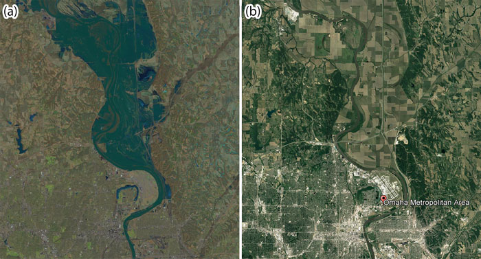
The catastrophic 2019 flooding in the U.S. Midwest illustrates the human influence on flooding. It is the latest in a long line of recent major floods in the region [e.g., Tate, 2019] and highlights risks of the new climate reality. Yet blaming climate alone might be insufficient and misleading when attempting to understand flood risk over long timescales. In the 2019 Missouri River flood, many sites witnessed record-high river levels, but the damage was particularly severe in regions where the river’s capacity is reduced because it flows within an artificially shortened and straightened channel separated from most of its natural floodplain (Figure 1).
.

Changes in the ability of rivers to hold and convey floodwaters downstream (river conveyance capacity) do not affect the amount of water that flows through river systems during floods, but they do alter the probability of floods overtopping riverbanks or flood defenses [Slater et al., 2015]. These changes in river capacity are driven by interactions among hydrology, landscape, and climate and by the interdependencies of processes at different spatial and temporal scales. Humans are also inextricably linked to water resources and are now, more than ever, active participants in complex flood–river systems.
While studies attributing flood events to individual drivers can be valuable, ignoring interdependencies among these drivers as well as the effects of changing river morphology implicitly promotes simplified views of the challenges inherent to flood management. Further research must account for these interdependencies, study flooding from a transdisciplinary perspective, and make use of remote sensing and emerging technologies to overcome these simplified depictions to adapt effectively to future flood hazards.
A Network of Interacting Effects
Rivers naturally adjust their geometry (i.e., their width, depth, and slope), conveyance, planform (bird’s-eye-view outline), network extent, and drainage density to reflect changes in flows and sediment in the upstream catchment [Lisenby et al., 2018], and changes in flood inundation frequency caused by such changes are not uncommon. As such, fluvial systems have “memories” that record disturbances such as extreme events and human impacts within catchments, as well as progressive shifts in catchment wetness, climate, or tectonic uplift. This memory effect is propagated and altered through shifting river networks.
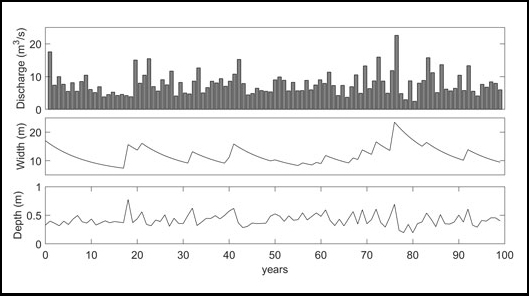
Fluvial systems also exhibit feedbacks in which processes (e.g., aggradation or widening) may be either amplified or dampened, resulting in shifts to new states or maintenance of equilibrium conditions (Figure 2). Some feedbacks have little to no visible effect, or perhaps only short-lived effects, and act to maintain stable channel morphology. In densely vegetated, stable river systems, some fluvial responses may be seen only locally and take years to decades to become evident. Other changes may be widespread over catchment and continental scales and take centuries to millennia.

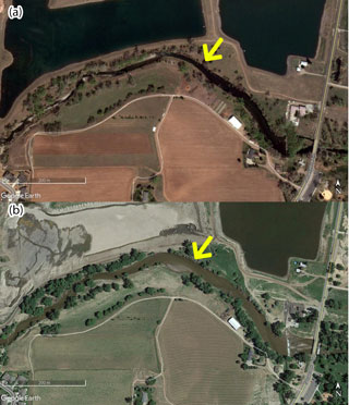
Flooding, which can produce chain reactions of subsequent events such as erosion of embankments, hillslopes, and terraces, as well as extensive sediment deposition [Wicherski et al., 2017] (Figure 3), can further alter fluvial geomorphic properties and create feedbacks that affect future flood properties (flood depth, frequency, duration, and spatial extent). Better understanding these flood properties means comprehending the physical template of the landscape (e.g., catchment properties, lithology, network properties, landforms, land cover), how that template has adjusted in the past, and how it is likely to continue adjusting.

Understanding feedbacks in river systems and exploring temporal variability in channel geometry, as well as the influence of flow variability and channel dynamics on long‐term channel form and conveyance capacity, involve long-standing questions. In particular, what controls changes in the frequency of overbank flooding around the world: the magnitude of river flows arriving from upstream or the ability of the river channels to convey those flows? A lot of uncertainty remains in determining causes and effects (i.e., forcings and feedbacks) in flood hazard studies. A more collaborative approach among the hydrologic, geomorphologic, atmospheric, and social science communities is needed to advance our understanding of how floods may change in the future.
The Human Contribution
For cultural, historical, and economic reasons, riparian societies—communities along riverbanks—have long sought to stabilize rivers. After long periods of pressure caused by channelization, bank protection, dredging, and water exploitation for irrigation [Sofia et al., 2019], many rivers in heavily populated regions are no longer free to adjust within their natural floodplains. Decreases in the conveyance of the Mississippi River system [Pinter et al., 2008], for example, have increased the magnitude of the 100-year flood by about 20% in the past 500 years, with three quarters of the elevated flood hazard associated with that change attributed to human modifications of the river and its basin, according to some estimates [Munoz et al., 2018]. These modifications are credited with protecting communities and croplands from flooding. However, artificial channelization has altered the relationship between discharge and river levels [Criss and Shock, 2001]. It has also accelerated the rate of land loss in the Mississippi River delta because artificial levees prohibit sediment from entering wetlands and greatly reduce sediment pathways into adjacent floodplain basins [Kesel, 2003], which necessitates increased investments in flood mitigation infrastructure and coastal restoration [Munoz et al., 2018].
Within such systems, socioeconomic trends influence water demand and management [Di Baldassarre et al., 2019], and human-imposed boundary conditions (reservoir operations, water supply, irrigation) alter local and global seasonal cycles [Haddeland et al., 2014]. These same boundary conditions are further altered by climate change [Fletcher et al., 2019]. And other feedbacks emerge when a change in flood hazard affects the social or political processes that determine mitigation or adaptation levels and the way we manage and exploit water. For example, should rainfall intensify, some models predict that certain communities might favor flood protection. Furthermore, there is empirical evidence that flood control structures tend to promote an increase in the vulnerability (including exposure) of societies, which, paradoxically, often results in increased flood risk [Gober and Wheater, 2015]. Feedbacks caused by human adaptation strategies are thus very difficult to detect, track, and model accurately.
Engineering and Modeling Challenges
Engineers and flood modelers typically assume that an equilibrium relation exists between the long‐term average geometry of a channel and the supply of water and sediment to the channel. This equilibrium concept has been challenged [e.g., Bracken and Wainwright, 2006], but only rarely.
Yet assuming that river channels reflect historical distributions of streamflow and sediment supply ignores that flows and sediment distributions also change in response to climate change, climate variability, and anthropogenic influences upstream [Sofia et al., 2019]—in other words, it ignores that the notion of stationarity does not apply to river systems [Milly et al., 2008]. Climate change, for example, has triggered and accelerated a multitude of hydrologic effects, including changes in the frequency of precipitation extremes [Donat et al., 2016] and in the rate and amount of water exchanged between the atmosphere, land, and water bodies. These phenomena, in turn, raise concerns about increasing river flooding and associated economic losses [Blöschl et al., 2019].
The interacting effects of climate change and sedimentation on river systems can lead to nonlinear responses that may produce more severe flooding. Accurately modeling these sorts of nonlinear responses, and their resulting impacts, is a substantial challenge for future work.
A Perspective Shift to Improve Flood Modeling
Hydrodynamic models typically separate slowly varying boundary conditions of river systems (by using static digital elevation models) from rapidly varying hydrological processes and conditions. We suggest that this approach may no longer be appropriate for estimating future flood risks to people and infrastructure in the Anthropocene. Research has highlighted how altered flows and river network properties function as nonlinear filters that fundamentally change the frequency and magnitude of flood events [Sofia et al., 2019; Slater et al., 2015; Criss and Shock, 2001]. Which one drives the other: changes in the water or changes in the landscape? Feedbacks between hydrologic and geomorphologic processes make this a tricky question to answer, but acknowledging this dichotomy fundamentally challenges the basic assumption of river stationarity used in flood risk analysis.
Current flood models do not account for the potential for floods to be enhanced by altered channel conveyance. This adds bias to decisions based on model results that should help steer development away from high-risk areas. Many flood risk mapping studies calibrate inundation estimates by combining contemporary surveys with historical flood outlines, which may lead to underestimation of the magnitude and frequency of floodplain inundation in aggrading systems.
The drivers of river flood risk are multidimensional, interdependent, and dynamic, so the search for sustainable solutions must be holistic and transdisciplinary. Effective adaptation strategies must combine flood protection infrastructure, process-based solutions, and risk-financing schemes to manage future floods and buffer their impacts. Research to inform this effort should integrate riverbed dynamics into flood risk assessment procedures and quantify associated uncertainties, and should also focus on bidirectional feedbacks between humans and water systems.
This research will benefit from the use of remote sensing technologies and exploit the available wealth of digital information, which will help in applying our understanding of geomorphic processes—often based on observations of past or current conditions—in the rapidly changing future [Sofia, 2020; Viles, 2016]. Thanks to data sharing, digital information, and new survey techniques, we can piece together the history of landscapes by studying landforms and sediments and how they’ve interacted, and we can understand processes that have molded the landscape. We can also provide quantitative analyses to describe rivers and the processes that have shaped them at various spatial and temporal scales [Piégay et al., 2019]. And we can identify human signatures in the landscape and model feedbacks between human and natural processes.
Finally, improved collaboration among scientists from different fields (hydrologists, geomorphologists, climate scientists, and flood modelers), as well as with surveyors, engineers, land managers, and the public, will be vital in planning and producing the needed holistic research—and in communicating the results to communities that will be affected by real-world decision-making. All told, these efforts will enable society to develop climate adaptation practices that lead to more resilient operations and infrastructure that are fit for an age of climate extremes.