Multi-risk information system initiated under the coordination of DLR to continue disaster risk management support in South America

The use of multi-risk information systems is crucial in confronting the increasing risks posed by natural hazards. In some cases, risk is increasing due to inadequate land-use norms or regulations that allow for the construction of infrastructure in areas exposed to such natural hazards. In other cases, vulnerability increases due to lack of awareness or extreme poverty. The need to address risks from the point of view of multiple hazards is necessary to contribute to sustainable development and has been incorporated as an essential element of the Sendai Framework for Disaster Risk Reduction 2015-2030. For this purpose, the RIESGOS 2.0 project was launched in March 2021. Under the coordination of the German Aerospace Center (DLR), the project builds on the accomplishments of its predecessor - RIESGOS - as a multi-risk information system that models and simulates natural hazards to support disaster risk management in South America.
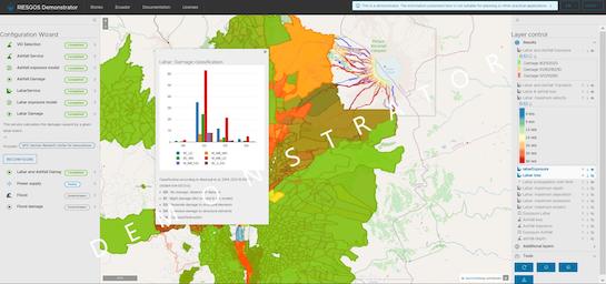
In the past, risk information systems oftentimes targeted natural hazards as isolated cases and avoided to address their interactions. This approach could lead to inefficient disaster risk management in communities in many regions of the world. In order to fill this gap, the RIESGOS project was launched in 2017. Funded by the German Federal Ministry of Education and Research and under the coordination of DLR, RIESGOS was a project that shifted from a single- to a multiple-risk assessment approach to natural hazards. It granted disaster managers in the Andes region the capacity to model and simulate natural hazards and enforce suitable adaptation measures to minimize their impact and risk. Specifically, it provided access to the RIESGOS demonstrator, a web-based platform that allows users to analyse and assess the impact of earthquakes, landslides, volcanic eruptions, floods and tsunamis and their interactions in particular at-risk regions in Chile, Ecuador and Peru. Following the positive feedback of RIESGOS and its expiration at the end of February 2021, the continuation of the project was launched on 01 March 2021.

RIESGOS 2.0 builds on the accomplishments of its predecessor by collaborating with project partners from research and development (R&D). Elisabeth Schöpfer, Project Leader at the DLR Earth Observation Center outlines the goals of RIESGOS 2.0 for the duration of the project: “Over the next three years we will jointly address open, central research questions, substantially expand our approach and strengthen the potential for practical implementation". This includes fine-tuning the RIESGOS demonstrator to “integrate elements of the platform into country-specific information systems” in order to facilitate local disaster risk management. Efforts by the project partners will also focus on assessing and quantifying any “uncertainties and inaccuracies discovered in the models” to improve analysis. RIESGOS 2.0 signifies an effort by DLR and its project partners to nourish and maintain strong and long-lasting relationships with developing countries in South America and at the same time strengthens R&D capabilities and competitiveness in Germany.