Protecting those most vulnerable: CMCC presents high-resolution projections of future climate for small islands and other areas at high risk

Complex orography and dependence on localized climate patterns can hinder projecting the future climate and identifying adaptation and mitigation measures for vulnerable territories such as the Macaronesian archipelagos and other small islands. A new study, led by CMCC researchers, uses innovative approaches to provide detailed and coordinated climate information over small islands which in turn helps support the development of adaptation strategies and mitigation measures, which are crucial for safeguarding these regions from the impacts of climate change.
Islands are among the most climate-vulnerable regions in the world as they are forced to come to terms with major threats including rising sea levels, tropical and extratropical cyclones, increasing temperatures, and shifting rainfall patterns. However, current global climate models (GCMs) struggle to accurately capture the small-scale processes that shape their climates.
A new study, led by CMCC researcher Marianna Adinolfi, in collaboration with a team of researchers from ETH, uses novel and innovative approaches – involving km-scale models captured in the figure below and compared with global and regional models – to address the gap in producing relevant climate projections over vulnerable territories like the Macaronesian archipelagos and, more in general, over small islands that are particularly vulnerable to climate change due to their complex elevation-dependent behavior of temperature and precipitation also associated to local climate patterns.
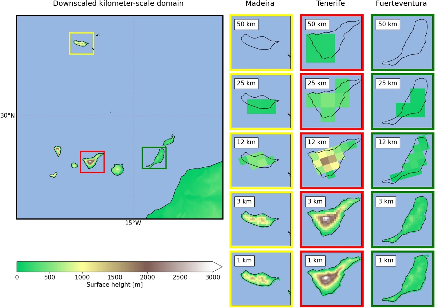
The use of km-scale simulations is demonstrated to be essential to properly represent orography, temperature and precipitation signals over the Macaronesian islands, which are characterized by an elevation-dependent behaviour that is not consistently represented at coarser resolutions. Source: Adinolfi et al 2025
“This gap can now be addressed thanks to the convection-permitting climate models and collaboration among organizations,” says Adinolfi, who explains that the results provided by the study reveal ways in which to exploit detailed climate information from different dynamical downscaling approaches, underscoring the importance of coordinated km-scale climate simulations as they are able to reveal detailed patterns in temperature and precipitation that coarser models fail to capture.
“The simulations fill a significant gap for local climate services: although it is a multi-model study, the need for more robust and coordinated km-scale modelling initiatives is highlighted by the encouraging results,” says Adinolfi. “Moreover, a suitable strategy to reduce uncertainties in climate projections over Macaronesian islands is suggested, in favour of the usage of models with a spatial resolution in the range of 1–4 km and a defined protocol with common forcing data, nesting, domain, simulation set-up and periods.”
Representing the bedrock for km-scale modelling over the area in question allows CMCC to play a pivotal role in editing and submitting the proposal to the WCRP CORDEX endorsement of the Flagship Pilot Study Convection Permitting projections focused on island processes (FPS-I-Mac), that was coordinated by the local meteorological service and successfully approved in December 2024.
“This study is based on CMCC’s long expertise in climate downscaling activities, and on its active participation in the CORDEX Community, and specifically the EURO-CORDEX initiative and different Flagship Pilot Studies, with a specific focus on assessing and describing the impact of climate change and its evolution in the Mediterranean region,” says CMCC researcher and professor Paola Mercogliano. “CMCC’s involvement was also supported through its collaboration in the CLM community – since 2008 – which led to the development and improvement of the COSMO and ICON regional climate models. In addition, the downscaling activity is now enhanced by studying how machine learning techniques can support the advance of dynamical downscaling, on improving reliability of climate data and projections to address emerging social needs.”
Underpinning the current differences in country-to-country adaptation capability and providing European decision makers with access to detailed and accurate information, regardless of geographical location, is crucial for safeguarding at-risk areas from the impacts of climate change.
By highlighting the gaps in global climate data coverage for small islands, whilst at the same time advocating for international collaboration to ensure equitable access to robust climate information and suggesting coordinated approaches, this study provides the groundwork for addressing these issues and creating more robust, sustainable and coordinated km-scale modelling in areas at high climate risk worldwide.