Wildfire hazard assessment maps can help communities build safer neighborhoods, prioritize mitigation resources, and adapt to wildfire.
By Kimiko Barrett
Congress directed the U.S. Forest Service to publish national, fine-scale maps of wildfire hazard in 2020. When calibrated at the local scale, wildfire hazard maps can guide community planning around wildfire risk and encourage safer development.
Several concurrent trends—climate change, fire exclusion policies, and increasing home development in wildfire-prone lands—are accelerating wildfire risks to people and homes. As the risks rise, so do the costs and impacts to communities.
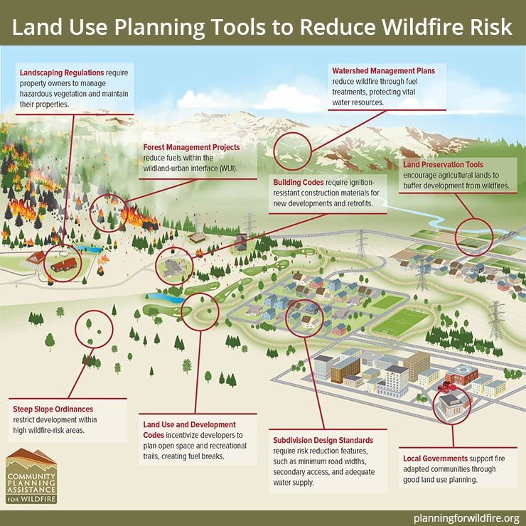
Understanding where wildfire is likely to occur, how it behaves under extreme weather conditions, and where people live in relation to areas of high risk is critical in reducing wildfire risk. Tools such as land use planning, zoning ordinances, building codes, and subdivision regulations can mitigate wildfire risk by influencing the location, design, and maintenance of homes and property.

Land use planning tools such as steep slope ordinances, building codes, and subdivision design standards can help communities be better fire-adapted.
Wildfire hazard assessments help prioritize mitigation efforts
Wildfire hazard assessments can help determine where and what type of land use planning tools and regulations are needed to reduce risks. Hazard assessments incorporate spatial models of wildfire likelihood and intensity based on characteristics like weather, topography, fuels, and historic fire occurrence.
The maps resulting from a wildfire hazard assessment can help communities to:
- decide where development should be encouraged or avoided;
- justify where regulations may be applied differently across the landscape;
- establish authority to make codes enforceable;
- require adequate fire protection standards;
- identify permitted and conditional land uses in higher risk areas;
- prioritize fuel reduction efforts;
- educate and communicate risk to the public; and
- empower county and city staff to take action.
Wildfire hazard assessments can also be used to strengthen and justify funding requests in grants and proposals, such as support cost-benefit analyses, fuel treatments, and other activities that strengthen fire-adapted communities.
Mapping wildfire hazards at the community scale
In 2015, the Community Planning Assistance for Wildfire (CPAW) program was established to help communities better plan the wildland-urban interface. In partnership with Wildfire Planning International and the U.S. Forest Service Rocky Mountain Research Station (RMRS), CPAW provides communities with land use planning recommendations, training, custom research, and wildfire hazard assessments.
The CPAW team, including spatial fire analysts with RMRS, works closely with community experts to identify, assess, and map areas of wildfire hazard at the local scale. Land use planners, fire personnel, emergency managers, and other stakeholders then use the maps to mutually determine areas of concern, decide on appropriate regulations and mitigation strategies, and direct resources accordingly.
While many wildfire hazard assessments are modeled at the landscape scale, the CPAW maps generated by RMRS are refined to be useful at the neighborhood, community, and county scale. The models are vetted by local subject matter experts and calibrated with local data so that the maps reflect the realities of wildfire behavior on the ground.
A case study: Mapping wildfire hazard in Chelan County, WA
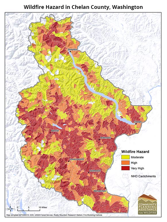
Chelan County is one of Washington’s fastest growing counties. It has experienced some of the most destructive wildfires in the state’s history. Following the historic 2015 wildfire season that destroyed dozens of residences, Chelan County joined the CPAW program. In partnership with CPAW, RMRS provided a hazard assessment for the county, incorporating local expertise and conditions.
But RMRS spatial fire analysts were faced with a unique challenge when they first modeled Chelan County’s wildfire risk. Preliminary model results misrepresented the fire risk near ravines that line hillsides around the community.
Chelan County residents often toss their tree and orchard clippings into backyard ravines that border many neighborhoods. After years of accumulation, these ravines become heavily loaded with dry timber and fuels that can intensify wildfire behavior. Effectively serving as a wick, the ravines drive the wildfire directly into the surrounding neighborhoods, as was the case with the Sleepy Hollow Fire in 2015.
Because a standard fuel type was assumed for the ravines in the preliminary modeling analysis, wildfire risk in Chelan County was initially misrepresented. After conversations with local fire personnel, however, RMRS recalibrated the model to capture tree and orchard clippings in the ravines. Final models more accurately reflected the true nature of wildfire behavior in the community.

Wildfire hazard in Chelan County, Washington as mapped by the Rocky Mountain Research Station through the Community Planning Assistance for Wildfire program.
By collaboratively reviewing the map with local stakeholders, RMRS strengthened the accuracy of the map and secured buy-in from the community. The process of developing the map itself facilitated partnerships among stakeholders, forced clarifying conversations around risk factors in the community, and helped develop a common framework for understanding community risk.
“I can’t emphasize enough the value of convening multidisciplinary professionals from various agencies to work together on the development of risk mapping - Steve King, Economic Development Director, City of Wenatchee, Washington, in his 2017 Testimony to Congress
Mapping wildfire hazard for the nation
Wildfire hazard assessments complement the land use planning process and, when locally calibrated, can help guide the direction of growth in the community. Just as Chelan County and the Community Planning Assistance for Wildfire program have benefited from wildfire hazard assessments, many other communities and organizations will soon have access to maps and data across the country.
The 2018 Omnibus Bill directs the U.S. Forest Service to complete a national wildfire hazard assessment in 2020 to increase the availability of hazard data nationwide. For the first time, consistent data about wildfire hazard will be available across the United States. The national wildfire hazard assessment can serve as a baseline from which communities can customize and calibrate wildfire hazard maps.
By understanding where wildfires are most likely and where risks are highest, communities can better plan the built environment, direct mitigation resources, and adapt to a future living alongside wildfire.