Informing key multi-hazard risks to the DRM decision makers
Agriculture plays a vital role in Moldova's economy, making it highly susceptible to the impacts of drought and climate change. The country has grappled with severe drought conditions since 2021, posing significant threats to its agricultural productivity. The Anenii Noi region, renowned for its fertile chernozem soils, is particularly vulnerable. These nutrient-rich soils are crucial for crop cultivation, but prolonged dry spells can lead to their degradation, compromising soil quality and health.
As drought persists, crop yields may decline, and the available food products could become scarce, driving up prices for both producers and consumers alike. This scenario illustrates the cascading effects of drought and climate change on the agricultural sector, the economy, and ultimately, food security.
In order to understand the impact of these phenomena, IMPACT has partnered with the STRIVE Consortium, made up of Acted, Libraries Without Borders, and REACH (an initiative of IMPACT and Acted), and funded by Agence Française de Développement (AFD), to perform an Area-Based Risk Assessment (ABRA). The ABRA used geospatial data to identify natural hazards and, risk hot-spots settlements were identified to inform risk-sensitive planning and programming activities in four communities in Anenii Noi raion for social vulnerability through in-person interviews.
Nearly 74% of Moldova's territory is agricultural land, and 70% of the rural population identify agriculture as the primary source of their livelihoods. Changes in this sector can lead to issues with food security, sanitation, development of diseases, increased cost of living, and stress on energy sectors. Drought, in particular, can increase the risk of some natural hazards, such as wildfires, as well as potentially increase the severity of flooding.
Arable land occupies 55% of Anenii Noi raion, and agriculture in the area is classed as "high risk" for an increased impact of agricultural pests, diseases and weeds, increased irrigation requirements, increased soil erosion, salinisation, desertification, and increased flood frequency and intensity. These risks are all related to climate change, and could potentially change both the landscape and yields of agriculture as well as exposure to natural hazards for the population, who may have differing abilities to respond and recover based on their demographic profiles and available resources in the raion.
Hazards examined in the ABRA were wildfires, drought, heat and cold waves, floods, deforestation, soil erosion, and air pollution, as well as hazards such as earthquakes, severe weather events, landmines, and diseases and pandemics. Climate change trends were analysed to understand the potential changes in temperature and precipitation in Raion Additionally, resources such as hydrography, wastewater and waste management in the Ţînțăreni landfill, gas and oil supply infrastructure, and the electricity network were contextualised for communities across the raion to identify consumption, accessibility, and spatial differences in use. Four sample communities were assessed for their social vulnerability to natural and man-mad disasters with the aim of understanding:
- Which hazards are most relevant to a given community?
- What are the forecasted impacts of these hazards for the selected communities?
- What coping tools does this community have?
- Where are vulnerable groups, such as families with children, persons with disabilities, and others and how do these hazards affect them differently?
Which hazards are most relevant to a given community?
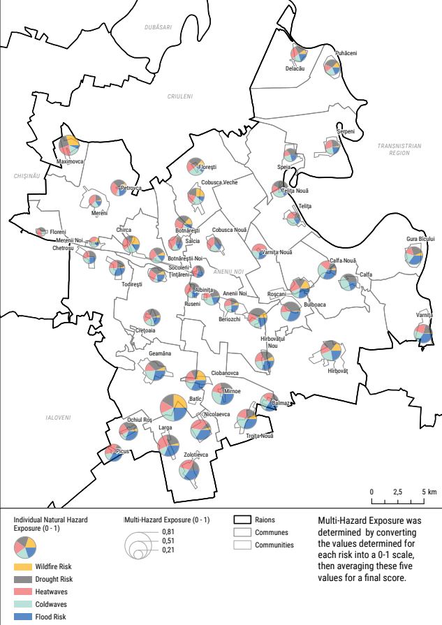
The major natural hazards that were identified during consultations and secondary data review for Anenii Noi Raion were: wildfire, drought, heat waves, cold waves, floods, air pollution and a short exploration of minor hazards. The identified drivers were: climate change, biodiversity loss, landcover change, and soil erosion.. These hazards were then combined into a "Multi-Hazard Index", which ranked communities from most-exposed (Batîc) to least-exposed (Floreni). Overall, communities in the south and center of Anenii Noi saw the highest risk factors, with the exception of Maximovca in the northwest.
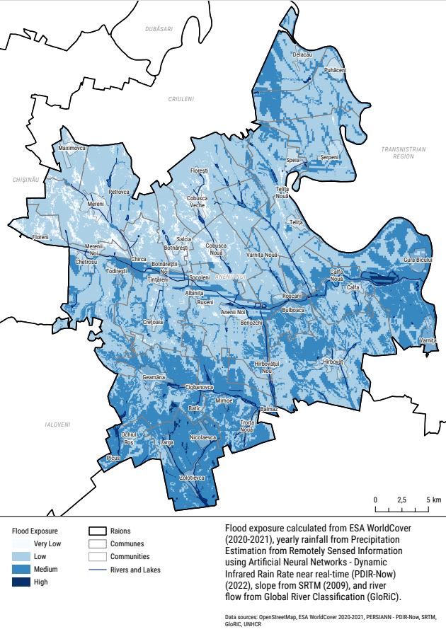
Flood was one of the most relevant hazards to communities, with 37 of 46 communities classed as "Medium" or "High" exposure to a flood hazard.
Improvements in infrastructure and land use planning can help to lower the exposure to hazards for communities: forest belt restoration, climate-smart agriculture for land management and irrigation, increased urban green space, insulation for homes and power infrastructure, and dikes and barriers can all help reduce the impact of natural hazards on a population.
Some hazards may have a positive impact in the local ecosystem, such as regular small fires reducing the probability of a large, high-intensity fire, or seasonal flooding increasing the available nitrogen, phosphorus, and organic material. For instance, floods transport vital nutrients, such as nitrogen, phosphorus, and organic material, to the surrounding land. When the water recedes, it leaves sediment and nutrients behind on the floodplain. This rich, natural fertilizer improves soil quality and has a positive effect on plant growth, thus increasing productivity in the ecosystem. However, these benefits come with risks such as managing small fires to prevent escalation. Additionally, increased nutrients in bodies of water can encourage algal bloom, resulting in aquatic "dead zones" that can impact agricultural productivity and livelihoods.
Not all hazards were included in the final analysis, and interplay between hazards may increase or decrease their impact on communities.
What are the forecasted impacts of these hazards for the selected communities?
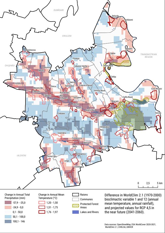
Climate change trends show an increased annual mean temperature for Moldova, including Anenii Noi raion, and changes in precipitation patterns: some areas are receiving more precipitation than usual, other areas are receiving less. This dynamic hazard can result in changes in the growing seasons for crops as well as impacting soil health, increasing risks for topsoil loss through erosion. Changes in these patterns can also affect levels of biodiversity, as territory may no longer support species that have relied on weather patterns, and pests can extend their territory to unprepared areas.
While these effects may seem insignificant in comparison to the devastation of a wildfire or flood, they can affect livelihoods and coping capacities for communities over the long term.
What coping tools does this community have?
Four communities (Anenii Noi City, Bulboaca, Floreni, and Gura Bîcului) were selected for comparison, and 314 household (HH) interviews were conducted to gain a more comprehensive understanding of the challenges that were faced. For the selected communities, "lack of coping capacity" was broken down into five factors: HHs with barriers to healthcare access, HH that were greater than 15 minutes' walk from an emergency shelter, HHs that were more than 10 minutes' drive from emergency services, HHs that had insufficient heating from November 2022 to March 2023, and HHs that had insufficient water in the previous 30 days from the time of interviews.
Gura Bîcului had the highest score in the Lack of Coping Capacity Index 0.672, suggesting that HHs in this community have fewer tools to cope with hazards than Anenii Noi City. Rural areas overall showed higher scores in lack of coping capacity, as they are generally located farther from medical assistance, shelters, and are more likely to experience shortages in heating and water.
While the index was developed for communities, unique HHs may be more or less able to cope due to their unique makeup and available resources. HHs may be affected by socioeconomic or demographic factors, such as HH income or a vulnerable member that requires more support.
Where are vulnerable groups and how do these hazards affect them differently?
Vulnerable groups were selected based on seven socioeconomic factors: HHs with refugees, a vulnerable head of household (HoH), HHs with more than three children, HHs with members who were over 60 years of age, HHs with persons with disabilities (PWD), HHs with at least one adult who is unemployed, low-income HHs, and HHs who were reliant on agriculture.
These factors were chosen to identify members of the household who may have higher support needs in an emergency (such as children or PWDs), as well as a household that is less able to absorb an economic shock derived from disasters.
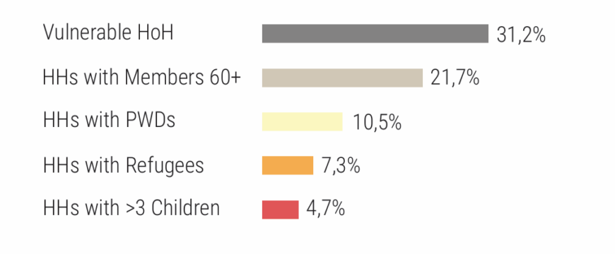
The most common type of vulnerability was a "vulnerable head of household", which was determined as a single parent or a female HoH, which was present in 31.% of assessed HHs. Floreni and Gura Bîcului had the highest rates of susceptibility overall, particularly due to the presence of vulnerable members of the household.
In addition to potentially being physically farther from assistance, rural communities may also have fewer options for fulfilling the support needs of vulnerable members of the HH. Planning can become more difficult, especially if finances are more limited.
While all communities are prone to natural hazards such as wildfire, flood, climate change, or air pollution, some communities and HHs have lower resilience and ability to cope. When planning for disaster risk reduction, it is essential to consider the demographic and socioeconomic profile of the community. Assessments such as the Area-Based Risk Assessment are tools that can be used to identify what the major hazards are for an area of interest as well as the unique population groups that can be affected in different ways.
Risk profiles can be compared across a region to identify spatial patterns and pinpoint communities that are at higher exposure or vulnerability to certain hazards. This spatial analysis allows for targeted disaster risk reduction planning and allocation of resources to the areas and populations in greatest need of support. By understanding where the highest risk areas are located and what demographic groups are most susceptible, development efforts can be directed strategically to enhance resilience in the communities facing the gravest potential impacts.